The Wine Map of Victoria by Max Allen

The Wine Map of Victoria by Max Allen
One side of the map shows Victoria and all its official wine regions, subregions and zones plus over 500 vineyards, wineries and cellar doors.
The other side of the map shows the Port Phillip area and Melbourne’s four closest wine regions: the Yarra Valley, Mornington Peninsula, Geelong and Sunbury. This Melbourne-area map has over 300 vineyards, wineries and cellar doors accurately mapped.
Both sides of the map include highway numbers and road names to help get you there. Also included are climatic maps of total annual rainfall, annual hours of sunshine, daily January temperatures and maps showing the State’s six most common grape varieties.
Find of the Week. —Judith Elen, The Weekend Australian, 29–30.9.2007
A brilliant solution. —Jane Faulkner, The Age, 25.9.2007
An invaluable companion. —Winsor Dobbin, Scoop Traveller Victoria + Tasmania, ed. 4, 2008
A godsend, and absolutely mandatory for planning a trip to the Victorian wine regions. —Ric Einstein, TORBWine, 5.3.2008
Published in 2007, the map is available folded, laminated, or flat (rolled) from the on-line store at Cardwell Cellars in Melbourne, Australia.
For sales outside of Australia, please contact the publisher at vW Maps.
Visit the map’s Facebook page to Like the map, learn more about the wine regions of Victoria, and find links to interesting articles about wine, wineries and vineyards in Victoria.
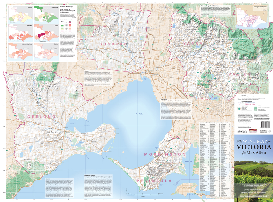
Reverse of the Map

Three Climate Maps

Max Allen’s Text