An essential function of geographic information systems (GIS) is to give us great flexibility in understanding the spatial relationship of one thing to another: Where is it, what’s close, and how far away is it? We can set the parameters that matter to us and generate the information we need, which can then be visualized in the most useful way.
In the case of this project, the client required a list of vineyards with their associated climatic indicators such as yearly rainfall and temperatures. In order to create the most accurate data possible, we mapped both vineyards and Bureau of Meteorology stations, and then we associated the vineyards with the climatic indicators measured at the nearest station.
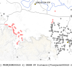
Our client wanted the results in a table of information, not a map, so in this case advanced cartography and data processing were the means to a different end. The illustration shows how the vineyard and weather station sites were merged in a map before a script, at bottom, was run that found the nearest weather station to each vineyard.


